|
The NOAA/INL Mesonet (MESOscale meteorological monitoring NETwork) began with a single station at the Central Facilities Area (CFA) in 1949 on what is now
known as the Idaho National Laboratory (INL). Between 1950-1970, six
on-site and 16 off-site monitoring stations were added to form an expanded observational network. The number of
meteorological monitoring stations continued to expand and change over the years for several reasons, including
1) support of various projects, 2) to provide meteorological data for emergency response models, and 3) to gain a
better understanding of the climatology of the INL and Eastern Snake River Plain. The current configuration of the Mesonet meets the needs of INL planners,
emergency managers, scientists, engineers, operations personnel, the local National Weather Service (NWS) Weather Forecast Office (WFO) in Pocatello, ID, and the general public.
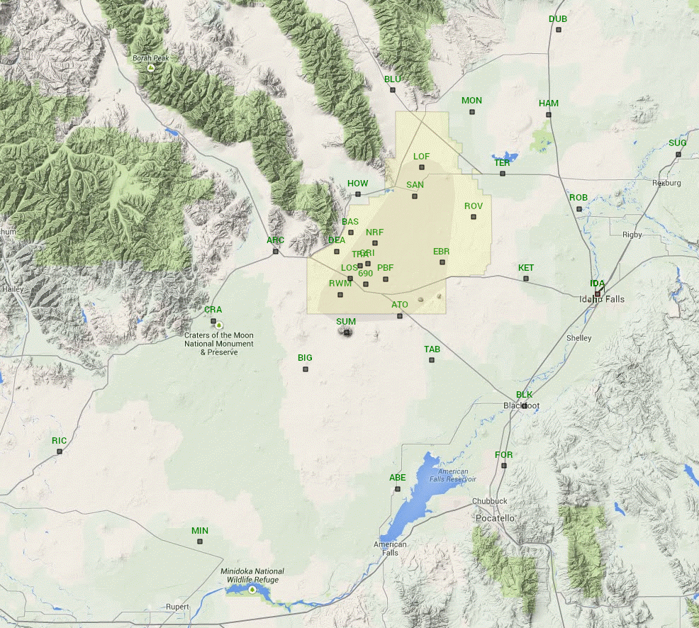
There are currently 34 fully automated meteorlogical observation stations in operation at the INL and surrounding area. Thirteen of the stations are located
within the boundaries of the INL. The remaining stations are sited at key locations throughout the Eastern Snake River Plain. Standard meteorological parameters are
measured at each Mesonet station. Click here for station
information, instrument height, and types of data being collected at each level. Most of the towers are 50 ft. tall. Three tall towers range in height from 150 to
250 ft. and are the "primary" on-site observation stations in each of the three INL microclimate zones.
These towers are at Grid 3/INTEC (GRI), MFC, and SMC. Shorter towers are on the summit of Big Southern Butte and Craters of the Moon National Park where aesthetic
restrictions permit only a 20 ft. and 30 ft. tower, respectively.
A map of the 34 NOAA/INL Mesonet stations is shown below. Several of the stations, called Community Monitoring Stations (CMS), are sited at schools and other places
frequented by the public to enhance relations with the local communities. The CMS stations were developed in partnership with DOE-ID, the State of Idaho INL Oversight
Program, the Shoshone-Bannock Tribes, the City of Idaho Falls, and the State of Idaho Transportation Department (ITD).
The CMS stations include a walk-up kiosk that displays current meteorological parameters and describes each of the measured variables.
Click here for a typical representation of the mesonet tower configuration and instrument layout including instrument specifications.
All meteorological instruments were carefully selected to meet required and generally accepted guidelines, including DOE/EH-0173T, Environmental Regulatory Guide for
Radiological Effluent Monitoring and Environmental Surveillance (1991), DOE Guide 151.1-1, Comprehensive Emergency Management System (1997); and ANSI/ANS 3.11-2005,
Determining Meteorological Information at Nuclear Facilities. Accordingly, air temperature and relative humidity are measured at all Mesonet stations at the conventional
6 ft. level. Wind measurements (speed and direction, 3-second gusts, and standard deviation of the wind direction) are made at the top of all Mesonet towers. For the three
tall towers, additional wind and air temperature measurements are measured at the 6, 33, 50, and 148 foot levels. Additional parameters measured at most stations include precipitation,
atmospheric pressure, and solar radiation. Still more wind measurements are made at the 6 ft. level at the Aberdeen, Kettle Butte, and Monteview stations in support of the U.S. Bureau
of Reclamation's Agrimet Program. Through a partnership with Agrimet, ARLFRD provides these additional meteorological measurements for regional crop water use modeling.
Mesonet data are recorded as averages, totals, or extremes over a 5-minute period. Wind speed, wind direction, air temperature, relative humidity, and solar radiation are measured
every 1-second and averaged over the 5-minute period. Precipitation is totaled for the same 5-minute interval. Maximum and minimum air temperatures for the same 5-minute period are
each selected from one of the 300 one-second scans used to assemble the 5-minute average. Wind gust is calculated as the maximum of a 3-second running average of the wind speed.
|
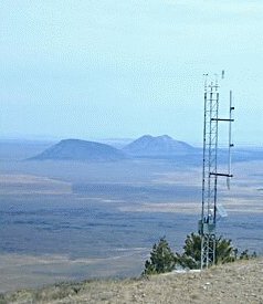
Meteorological tower on the summit of Big Southern Butte.
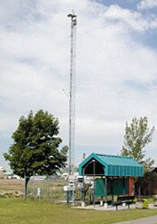
15 m meteorological tower on the Idaho Falls greenbelt collocated with the
Idaho Environmental Monitoring Program display kiosk.
|
